In my last post I discussed how survey archaeology is useful to gain an understanding of a city, in this one I want to show how it can be used to reconstruct the ancient landscape, in this case the landscape of Roman Wiltshire. Wiltshire is a good example for the benefits of landscape archaeology since it was extensively inhabited throughout the entire occupation due to the potential for agriculture. This means that the landscape is scattered with Roman villas and towns, but often in British archaeology these elements are often seen in isolation, rather than as part of a greater whole (Corney (2000) 33). This is why surveying the landscape helps to connect the dots that are on the map. The plan in this post is to focus on how one villa can have a large impact on the landscape and how the process of studying the landscape would occur.

I am going to the examine the villa at Truckle Hill (see Fig. 1), in 2008 a geophysical survey was undertaken to answer questions regarding the state of preservation and the accuracy of the original excavation report (Sabin and Donaldson (2008) 2-3). The site was excavated between 1859-1860 by George Poulett Scrope, a renowned geologist, and he discovered a large villa complex. Within the site there was the main villa building which had 16 rooms including heated baths, a courtyard, two sets of other buildings, and a cemetery (four graves were excavated) (Sabin and Donaldson (2008) 5). Scrope’s original report is stored in the Wiltshire Council Archives, and I have do not have access to it; however, the geophysical report by Sabin and Donaldson (which I do have access to) provides a good overview of the content and of the plans that Scrope made of the site.
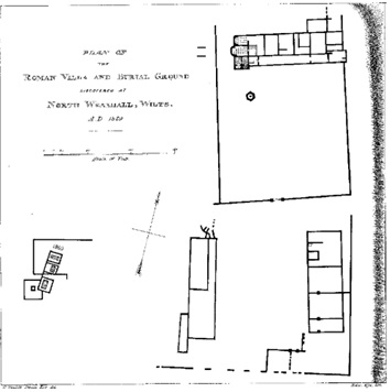
Scrope’s plans of the site help to explain why a more modern survey was needed to understand the villa site. The lack of a grid and the questionable scale provided make it hard to understand the site, the more modern survey will chart the site accurately and gauge the accuracy of Scrope’s plans. It was found out that the length and width of the main villa building were inaccurate, he recorded it as 180’ by 36’, when in fact it was 40m (131.23’) by 12m (39.36’) (Sabin and Donaldson (2008) 18). This was found out through geophysical survey, a non-invasive technique that uses a machine to measure either electric resistance or any magnetic signals, this allows archaeologists to see what is underground without damaging the archaeology. The inaccuracies the geophysics found suggests one of two things: either Scrope simply guessed the length or that his grids were inaccurately marked. Either way, the geophysical survey has built up our understanding of the villa and has corrected a 150-year-old mistake. This correction has made it easier for future archaeologist to locate the villa and fulfils one of the objective of the survey: “to determine the accuracy and validity of excavation plans produced in the mid-19th century”, this is important as many early excavations were basically treasure hunts on known sites were the important layers of archaeology were simply removed (Greene (1991) 55). And although the plans are deemed somewhat accurate by the modern survey team, this survey shows the need to return to older sites and update information, surveys are an efficient and effective way of achieving this goal since they can non-intrusively gain an understanding of a site.
A good example of why returning to sites is a good idea is that the older excavations can improve the state of the results, and although the excavation techniques of the 19th century leave a lot to be desired, due to the destructive nature and the fact that Victorian antiquarians often concentrate on spectacular remains rather than the importance of stratigraphy and datable evidence, they can throw up surprising results. Sabin and Donaldson report that Scrope’s removal of destruction debris has made their magnetometry results extremely clear, especially when the clearance has been adjacent to the walls (2008, 18). This indicates that debris was cleared from the main villa and one of the other buildings southeast of the villa had been cleared, which is probably the reason for the clarity of the results. The results of this part of the survey build on what was left by Scrope and confirm the value of his previous excavation at the site.

As I have previously mentioned, often in Victorian archaeology they tend to focus on the big and the spectacular. The modern survey considers the impact of Roman occupation on the indigenous population, which is school of thought which has developed in the late 20th century (Millet (2012) 44), the survey found evidence of prehistoric ditches and fortifications which would have been extant during the earliest Roman phase of the site (Sabin and Donaldson (2008) 22). This suggests continuous occupation from prehistoric times to the end of Roman rule in Britain, such a long-lived site would reveal a lot of information regarding how Roman culture was assimilated into the indigenous British culture. Or failing that it demonstrates that hill tops are the strategic position to occupy, and this transcends the culture that is dominant at the time. Wiltshire is well known for its prehistoric landscape, and it has to be remembered that this world didn’t disappear with the coming of the Romans, the indigenous population adapted and changed when invasions occurred, and in Wiltshire this is particularly clear, especially through diachronic surveys such as the one at Truckle Hill. This adaption from Iron Age farmstead to Roman Villa is particularly common in Wiltshire (Corney (2000) 35) and adds another dimension to understanding the ancient landscape. As with at Sikyon, the survey can create a picture of a site that has had a series of occupations through its history, allowing us to develop an understanding of several important transition periods, including the beginning and ending of Roman rule in Britain.
It could be argued that this survey could have gone even further than it did. It focused on the villa complex and a small surrounding area. Often Romano-British archaeology focuses on sites such as villas, forts and towns and not how they all interlock (Corney (2000) 34). The Sikyon survey aimed to reconcile both the city and the countryside, and to give it local context and, the idea that a polis existed in isolation from the countryside around it was proved to be inaccurate (Snodgrass (2012) 26), the same should be done in Britain, for villas are miniature economic powerhouses that will clearly have an effect on the landscape. Sabin and Donaldson mention the possible Iron Age structures and the possibility of a long period of occupation, but they remain within the bounds of the survey and they did not consider that the defensive enclosure is indicative of earlier control of the region during the Iron Age (Sabin and Donaldson (2008) 24). Corney states that in Wessex, where Truckle Hill is located, there is the continuity between the Late Iron Age sites and with Roman ones (Corney (2000) 35). Sabin and Donaldson’s suggestion of further surveying and excavation is necessary to understand the relationship between the villa and the land around it. Corney goes on to say that the boundaries of the Iron Age settlements with continued occupation are likely to be used by the Romano-British as well (2000, 37). The scale of this survey is why these essential questions have not been answered, it concentrated on just the villa and surrounding buildings, and the objective of the survey was to check the validity of previous excavation and this was achieved. In doing so it gave us a much greater understanding of the site and opened the door to further investigation, most likely a joint excavation of the site and further surveying of the wider area using both aerial photography and greater research with the topography of the area. What the survey at Truckle Hill shows is that although you will find out more about the site through a survey, if you focus on only one kind of survey, in a small area, it will lead to getting more questions than answers. This shows the superiority of multidisciplinary intensive surveys when you want to gain the best understanding of a site, but if you want to build on the lack of information about a site, this proves that a survey is useful for gaining an intimate knowledge of the site.
Further suggestions about how to examine the landscape around Truckle Hill could include an environmental survey, the By Brook River runs very close to the villa (see Fig. 1) and this could have had an impact on the positioning of the villa and any earlier settlements in the area. A survey that could analyse any pollen samples preserved in the water would help to recreate both the wild and agrarian landscape, and through surveying it may be possible to see whether the course of the river had changed and whether the depth was different in antiquity. This would help to understand possible uses of the river either as transport (small barges bringing goods to and from the villa) or as a way of connecting those that lived in the vicinity, because looking at figure 1, there are a whole series of Roman period sites along the By Brook and along the Avon, into which the By Brook flows. Understanding the natural environment that existed during this period is essential to asking valid questions and the site (Greene (1991) 84).
Survey archaeology is a useful tool for understanding a bigger picture than what excavation offers, it should be said that both techniques are important, since excavation can give an incredibly detailed idea of what a site can tell us. But in the case of landscapes, survey archaeology is able to help recreate the world of the ancients. Truckle Hill helps illustrate the versatility of surveying and shows ways to build on the work of others. Both the case studies I have examined, Sikyon and Truckle Hill, show the importance of context, and being able to place a site into the landscape, this is important to consider when examining how ancient people lived, since they were not isolated from others, but part of a wider historical landscape.
Bibliography
Corney, M. ‘Characterising the landscape of Roman Britain: a review of the study of Roman Britain 1975 – 2000’ in Landscape: the richest historical record, eds. Hooke, D. Amesbury: Society for Landscape Studies. 33-46.
Greene, K. 2002. Revised Edition. Archaeology: An Introduction. St Edmundsbury: Routledge.
Millet, M. 2012. Revised Edition. ‘Roman Archaeology’ in Classical Archaeology, eds. Osborne, R. and Alcock, S. Singapore: Blackwell Publishing Ltd. 30-50.
Snodgrass, A. 2012. Revised Edition. ‘Greek Archaeology’ in Classical Archaeology, eds. Osborne, R. and Alcock, S. Singapore: Blackwell Publishing Ltd. 13-29.
Illustrations
Figure 1. Map of Roman Activity in Wiltshire, the Villa I am focusing on, Truckle Hill, is highlighted in orange (from Corney 2000).
Figure 2. Scrope’s Original plan of the villa complex, the lack of a grid makes it hard to keep track of the site (From Sabin and Donaldson (2008) 6).
Figure 3. Results of the magnetometry geophysical survey, showing the villa and associated building and the possible prehistoric boundary ditch. The white circles are were the survey team could not scan due to trees. (from Sabin and Donaldson (2008) fig. 4)

You might enjoy reading “Two Possible Nymphaea at Truckle Hill, North Wraxall, Wiltshire” in AJ,Vol 170, 2013, covering the discoveries made in the By Brook valley, some 100metres from the villa site. The site was found largely thanks to a chance observation by Kerry Donaldson and Dave Sabin while out for a walk from Castle Combe! I have a pdf if you don’t have access to the AJ.
LikeLike
Thank you for the recommendation! I do have access, but thank you for offering me the pdf!
LikeLike